Brief Intro: Easy way to mount virtual react dom to GisMap under restricted accepting types circumstances
背景

业务需求基于 mapoboxgl 封装二维 gis 地图,支持打点,画线及绘制面,即业务上的坐标点、轨迹线条和电子围栏区域。
createPortal 原理
- Portal 将提供一种将子节点渲染到 DOM 节点中的方式,该节点存在于 DOM 组件的层次结构之外。
- 适合脱离文档流 (out of flow) 的组件,特别是 position: absolute 与 position: fixed 的组件。比如模态框,通知,警告,goTop 等
使用场景
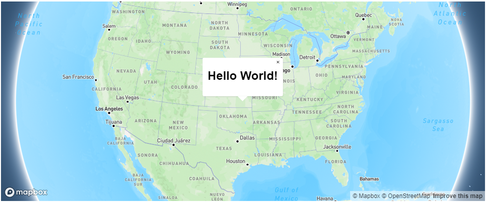
场景一:坐标点点击后弹框显示
官方示例 << 传送门
限制
- 接受类型有限(当前官方示例中仅写了 HTML 和 DomContent)
- 原生样式及标签写法较为麻烦
- 数据量庞大的时候难以受控单个点位
- 可扩展性不高,维护起来难度高
- 组件视角看,不方便开发绘制定制化的展示内容
扩展方式
1 | // 首先创建一个DOM容器,用来嵌入业务中传入的自定义内容组件 |
场景二:自定义图标组件渲染到 gis 地图上
背景
业务需要支持公司内部封装的图标组件渲染到 gis 地图上,通过调研发现可以使用 mapboxgl 的 Marker 进行标记点的添加,最后同样的方式挂载到地图上。
使用方式
1 | // 注意:因为要接受自定义图标组件,这里要挂载的父容器变成了markerComp |
弊端
地图组件内容本身要处理例如瓦片,
图层(layer),数据源(source),标记点、线条、面、图像等渲染以及原生事件,因此如果当 marker 点位过多的时候会影响地图加载速度。
解决方式
… 下篇文章